
Tanya and I recently returned from a 9-day trip to the Bend, Oregon area. While there, I’d hoped to get some shots of the nearby mountains and lakes. After several relatively clear days, during which I photographed at Smith Rock, wildfire smoke blew into the region. Some days were worse than others, but it did really put a damper on my plans. I was bummed, but figured it wasn’t the best time of year to photograph the mountains anyway because they has so little snow (South Sister had a decent amount, but Mount Bachelor was essentially bare). So instead, I spent most of my photography time shooting waterfalls and the Deschutes River where the smoke was much less of an issue.
Tumalo Creek is a tributary of the Deschutes River west of Bend. There are several scenic waterfalls on the creek, the best known being Tumalo Falls (note: Tumalo Falls, and indeed Tumalo Creek, is not located in Tumalo State Park). While the flow of Tumalo Creek is diminished by irrigation and water-supply diversions by the time the creek reaches the river, these diversions are all below the falls. And, being spring-fed, there is a good flow over the falls even in late summer.
There is an 8-mile loop trail that starts at Tumalo Falls and goes by six other waterfalls (or seven depending on how you count). Due to time, I did not do the entire loop, but rather did a 6-mile out-and-back hike to Middle Tumalo Falls, which also took me by Double Falls (which is really two different waterfalls, in my opinion).
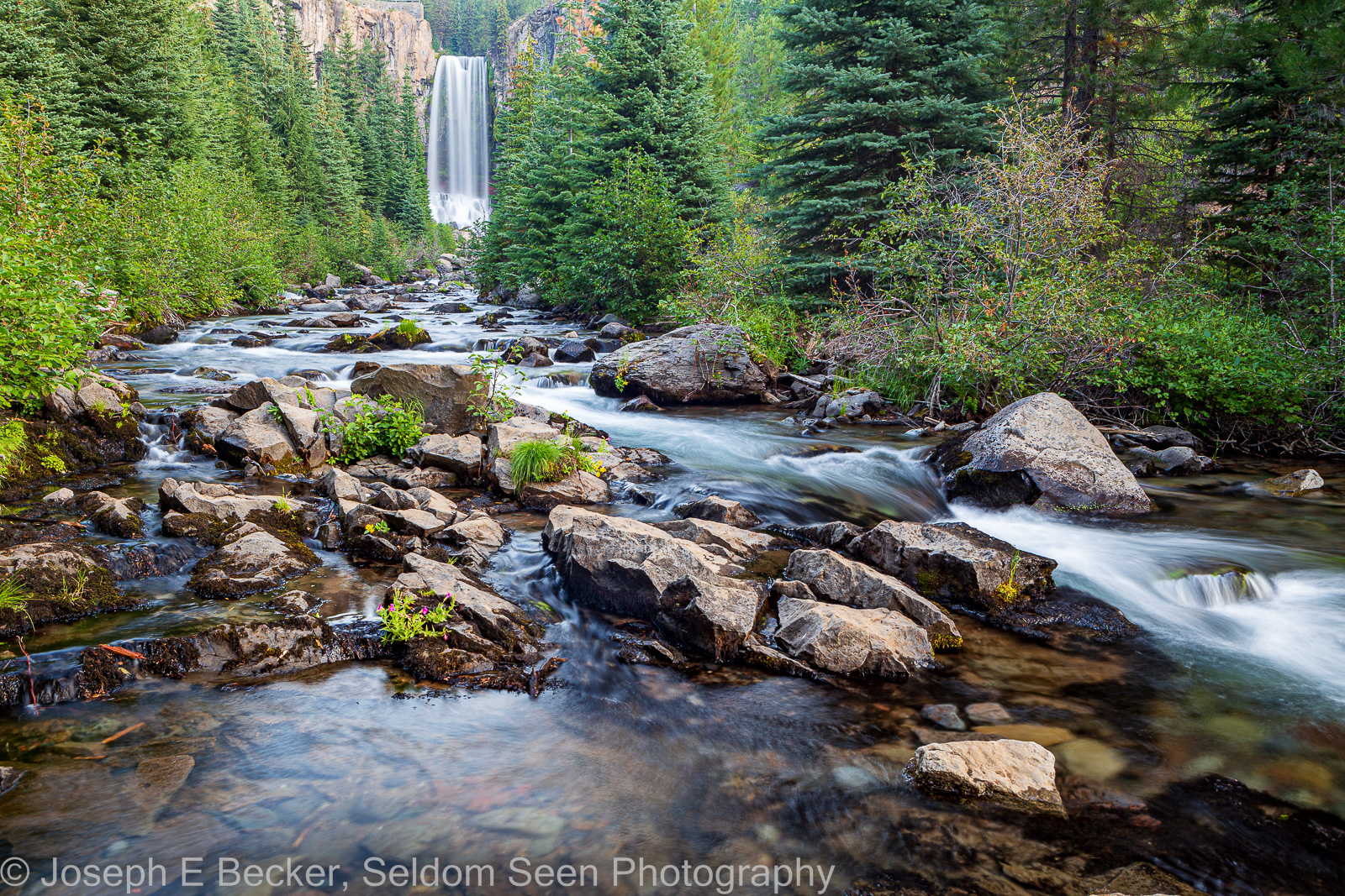
Tumalo Falls is considered one of the most photogenic falls in the State of Oregon. The view is good from the lower viewpoint near the parking lot (which fills early during the summer; additional parking is further down the road, with an official overflow parking lot a mile or more from the falls), but you can also work your way upstream from the bridge over the creek just before the parking lot on an unofficial trail for a view with the creek in the foreground (the featured photo above). The North Fork Trail, which forms half of the aforementioned loop, leads to an upper viewpoint at the top of the falls about 1/4 mile from the parking lot.
Beyond the top of Tumalo Falls, the North Fork trail continues, leading to the very pretty Double Falls, about one mile from the trailhead. Double Falls is really three waterfalls, two close together and the other a couple hundred feet upstream. The viewpoint along the trail is above the creek, on the edge of a canyon, looking down on the falls. The upper portion of Double Falls is about 300 feet further up the trail.

A mile or so further is Middle Tumalo Falls. Here the view from the official viewpoint is somewhat obscured by trees. However, it is fairly easy to scramble down to creek level for a closer look. Be sure to pack your wide-angle lens for all three of these falls.

South of Bend there are several other waterfalls. The Deschutes River southwest of Bend has three waterfalls, only one of which, Benham Falls, is readily accessible. Benham Falls, which appears like more of a very steep rapid than a waterfall, is a mass of white water shooting through a bedrock chute. The main viewpoint gives the only decent view from below the falls. Above the falls, there are several spots to shoot the top of the falls and other rapids above the falls, both above the river and at river level. Though located down a rough dirt Forest Service Road, Benham Falls get a fair amount of visitation.

For a more truly off the beaten path waterfall, try Fall River Falls, located in La Pine State Park. The road to reach this waterfall is not even marked (see directions on Photohound). Though not particularly impressive, there is a great swimming hole below the falls, and Fall River above the falls is very scenic.

There are about a half dozen waterfalls on Paulina Creek in and adjacent to Newberry National Volcanic Monument. The most popular is Paulina Falls, an unusual twin waterfall in the Newberry volcano caldera. Further down the creek there are a number of waterfalls, most of which are accessible only by hiking. The excepting being McKay Crossing Falls, which is located at the McKay Crossing Campground.

You can access additional information and see addition photos of these waterfalls on the Photohound website.

Leave a Reply