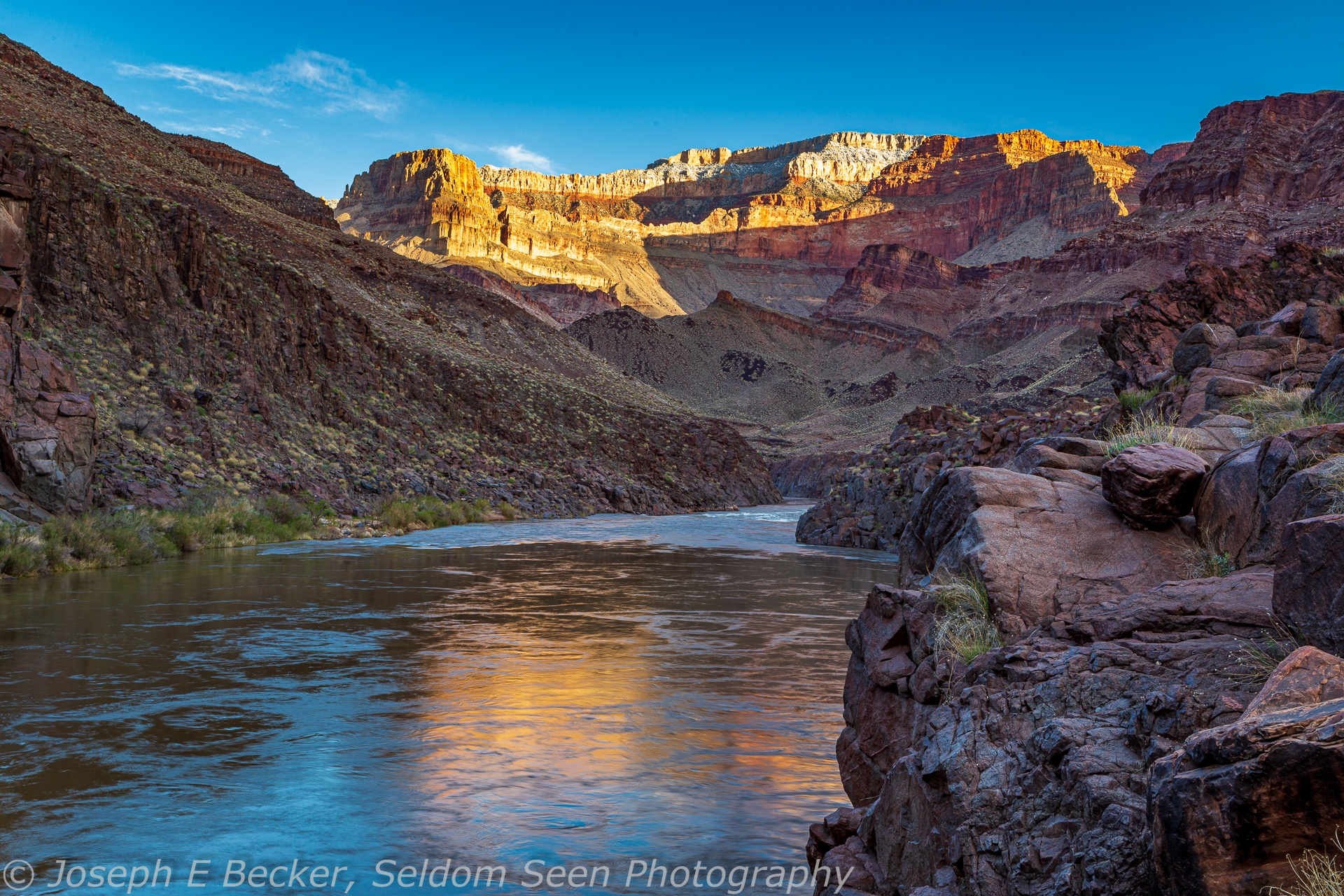

Before I get into the photo highlights of this section of the canyon, I want to discuss some basic geology of the canyon because the landscape is based on the geology. Below the Little Colorado River, the canyon changes as the Marble Canyon ends and the Grand Canyon proper begins. The look of the canyon, at least from the Colorado River, is controlled by geology. The river cuts through the bottom of the Paleozoic rocks that from Marble Canyon, across the Great Unconformity, and into much older, and softer, sedimentary rock. With this change, the canyon widens. Further downstream, the pre-Paleozoic sedimentary rocks are replaced by truly ancient metamorphic rocks and granite. These rocks are hard, and the canyon narrows.

The lowest Paleozoic rock formation is the Tapeats Sandstone. Just downstream from the Little C, groundwater seeping through the Tapeats has left salt deposits near river level on the Tapeats. These salt deposits, known as the Hopi Salt Mines, are sacred to the Hopi people, would still make occasionally make journeys from the canyon rim to harvest salt. The Hopi Salt Mines are off limits and rafts cannot stop in this section of the river. To take a good photo of the salt deposits, shoot with a telephoto lens from your raft, trying to keep your entire composition in the shade to prevent too much contrast when the white salt is in direct sunlight.
Below the salt mines, the canyon opens up as geology changes as described above. There are no significant rapids here, or any must see sights, just broad canyon views, sometime up to the rim, as you float downriver. Both at Tanner (mile 68.5) and Cardenas (mile 71) there are short hikes to ruins of ancient pueblo watchtowers that overlook bends in the river. The second of these overlooks the Unkar Delta, which contains many ruins (though they are not very photogenic).
The rapids start to pick up below the Unkar Delta. From mile 73 to 85, there are a series of rapids, including five big ones: Unkar (rated 6 – 7), Nevills (6), Hance (8-10), Sockdolager (8-9), and Grapevine (8). Hance, in particular, is big, dropping 30 feet in half a mile. Considered by many as one of the top three rapids in the canyon, many trips will stop and scout the rapid. The primary scouting point is high above the river on river right. From this spot, you will need a telephoto lens to shoot rafts braving the rapids, but the view of the river and rapids from the scouting point is quite scenic even without rafts and can be shot with a wide-angle or normal lens.

Shortly below Hance, the river enters the Upper Granite Gorge, where the river has cut down into the Vishnu Schist and Zoroaster Granite. These 1.7 billion year old rocks are the oldest in the canyon. The black schist and red granite make this section of the canyon very scenic, but also very hard, so the canyon (at least at river level) narrows forcing the water to speed up and the rapids to become generally bigger. This section includes Sockdolager and Grapevine Rapids.

Below Grapevine, you will come to the Kaibab Suspension Bridge, also known as the Black Bridge, and Phantom Ranch at river mile 88. Most trips stop at Phantom Ranch you can mail a postcard and buy an ice cream cone. Many trips transfer passengers here, with some leaving and hiking out to the South Rim, and others hiking down to join the trip downriver. Camps near Phantom of reserved for trips doing passenger transfers. On my trip in March, we dropped off four (including one of our boatmen, who had hurt his hand and had to be airlifted out) and gained three.

As you leave Phantom, you pass under the Bright Angel Suspension Bridge, known as the Silver Bridge. The river continues through the Upper Granite Gorge, narrow and fast. Anyone joining the trip at Phantom won’t have much time to relax, as there are several big rapids between miles 90 and 98.5, including Horn Creek (8-10), Granite (9), Hermit (8-9), and Crystal (8-10). The primary scouting spot for Horn Creek is similar to Hance, fairly high on the hillside, providing a nice view of the canyon and rapid, but not good for photographing whitewater action without a telephoto lens.
Both Hermit and Crystal provide good opportunities for photographing rafts braving the rapids close up. The scouting locations are very close to the large waves and holes in the river, and you can get decent photographs of rafts shooting the rapids with a short to medium telephoto lens, or even a normal lens. Guides may not necessarily want to scout Hermit, so you may want to ask to stop and photograph the other boats in your group going through. On the other hand, Crystal, is scouted by most trips, and you can easily position yourself by the monstrous hole that makes Crystal famous.

Crystal is the last big rapid for awhile, though there are many smaller rapids in the canyon below Crystal (including a series named after gems). At river mile109, there is a short hike to Shinumo Creek Falls. These falls are reportedly not very photogenic (I have never stopped there). However, next waterfall is very scenic. At mile 116.5, there is a short trail/scramble into Elves Chasm. You’ll need a wide-angle lens to get the best composition. Every river trip seems to stop here, so you may not be alone, patience is the key to getting your shot.

At approximately river mile 117, the river exits the upper gorge and enters the Stephen and Conquistador Aisles, where the Tapeats Sandstone again lines the banks of the river. At mile 120.5 is Blacktail Canyon, a lovely slot canyon through the Tapeats Sandstone with a small waterfall. Just past Blacktail is the Conquistador Aisle, the longest (3 miles) straight stretch in the Grand Canyon. By river mile 123, the river cuts into the older schist and granite and enters the Middle Granite Gorge. This gorge is much shorter than the upper (or lower) ones, ending at about mile 131. Within the gorge is Bedrock Rapid (8), the only rapid in the canyon formed directly on the bedrock of the river bottom.
Leaving the Middle Gorge is the Deubendorff Rapid (7-9), is Stone Creek at mile 132. A short hike up the creek from the beach on river right leads to a pretty waterfall that is definitely worth shooting if your group stops here. At river mile 133 is Tapeats Creek. From here, its a great hike along the creek up to Thunder River – a large spring that gushes straight out of a cliff face creating a large waterfall. The hike is about 3 miles from the river.
Below Tapeats Creek at river miles 134 to 135 is the Granite Narrows. Here, again, the river cuts into the harder older rocks, forming a short stretch of narrows, at one spot only being about 100 feet across. As you come out of the narrows, Deer Creek enters on river right. Deer Creek plunges over a 180-foot waterfall, just a short distance from the river. Above the falls, the creek cuts through a slot canyon to an incredibly beautiful place call the Patio.
The entire falls is not visible from below (or above), and a wide-angle lens is required to place the visible portion of the falls in your frame. Deer Creek Falls (and the narrows above the falls) are one of the most popular stops on Grand Canyon rafting trips, so there is a good chance you will not be alone when photographing the falls. Additionally, during warm weather, the pool at the base of the falls is a popular swimming hole and, also, many people like to stand directly beneath the falls. Therefore, you may need to incorporate people into your composition or that multiple shots and use selective editing to create a composite without people.
There is a rafting campsite on the opposite of the river a short distance downstream. If camping there, you can get an excellent shot of the falls with the river in the foreground by hiking back upstream to a spot directly across from the falls.
Above the falls is Deer Creek Narrows, a deep, narrow canyon where the creek curves through brownish-red striated sandstone, creating a stunning slot. You will need to climb the short, steep trail south of the falls to access the narrows and the Patio. As the trail comes out at the top of the narrows, there is a great view up canyon of the river . The trail through the narrows winds along the western canyon wall above the slot canyon. There are several spots along this section of the trail with good views down into the gorge. When shooting here, take care along the edge of the cliff. Along the non-gorge side of the trail through the narrows there are several spots with hand-print pictographs. Some are rather faint, and in general, the pictographs are easier to spot when walking toward the river.

The narrows opens up in the Patio area, where are lots of compositions of small waterfalls, the creek, rocks, and cottonwood trees and other vegetation using wide-angle to short telephoto lens. Because of potential contrast issues, Deer Creek Narrows and the Patio are probably best photographed on cloudy days or when completely in shade. This may require using higher ISOs to limit shutter speeds.
The Grand Canyon continues for nearly another 140 miles past Deer Creek. I will cover this lower stretch of the canyon in the fourth and final part of my series.


Leave a Reply