
Stanley, Idaho is a small town in the heart of the Sawtooth National Recreation Area located near the headwaters of the Salmon River. The views of the Sawtooth Mountains in the area around Stanley are amazing, with the aptly named mountains abruptly rising thousands of feet from the Salmon River valley floor. There are many good photo locations in the Stanley area. Below I describe a few that I found in the three days I spent there last month.
Redfish Lake

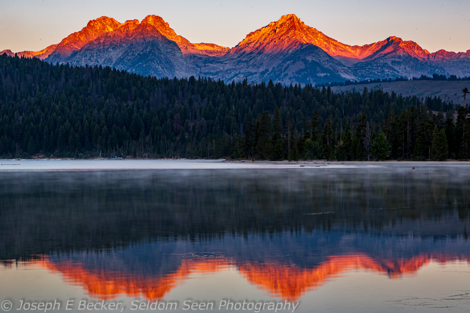
A few miles south of Stanley is Redfish and Little Redfish Lakes. These lakes are named after sockeye salmon, turning red in fresh water while swimming 900 miles in from the Pacific Ocean, who spawn in the lakes. Today, only a handful of salmon can make the journey due to man-made obstacles, so the natural run is now supplemented with a fish hatchery. Redfish Lake is the larger and more developed of the two.
The view of the Sawtooth Mountains doesn’t get much better than from the Redfish Lake shoreline. The best time to capture the scene is in early morning while the lake is calm and the mountains reflect in the water, and prior to any motorboat activity on the lake. The light is not good in the afternoon, and sunset shots will only work well if there are colorful clouds in the sky.
There are several accessible spots along the shoreline to shoot, but perhaps the best spot in near the swimming area at the Outlet Picnic Area and Campground. East of the swimming area, the shoreline curves toward the mountains. Northwest of the swimming area, there are several logs in the water that can serve as foreground elements. Use a wide-angle lens to capture the entire set of mountains or a normal to short telephoto lens to make the peaks more prominent in your frame.
Little Redfish Lake

Like it’s bigger brother lake, Little Redfish Lake presents a wonderful view of the Sawtooth Mountains, especially in the early morning when the water is calm. The best location for shooting the lake and mountains is along the shoreline of the Chinook Bay Campground on the eastern end of the lake. You will need a wide-angle lens to capture the scene here, or alternatively you can stitch several images together to create a panorama. The best light will be in the morning, particularly at sunrise. Similar to Redfish lake, sunset shots will only work if there are colorful clouds in the sky lit by the setting sun.
To reach the Redfish Lakes, turn onto Redfish Lake Road from State Highway 75 about 4.3 miles south of Stanley. For Little Redfish, turn into Chinook Bay Campground after about 0.4 miles. Parking can be difficult if not camping at the campground (alternatively, you can camp at the Mountain View Campground, slightly further down the road, and walk to back along the shoreline). Parking on Redfish Lake Road is only allowed in designated areas and parking in the campgrounds is reserved for campers. The campgrounds are both first-come first-served and typically fill up early in the high season. Both typically close in mid-September.
To reach Redfish Lake, continue down Redfish Lake Road. At the round-about, take the second exit. In less than a mile, take the first right turn, and then another immediate right into the Outlet day-use area parking. From the southern end of the parking lot, it is a short walk to the beach.
Pettit Lake

Another scenic, easily accessed lake in the region is Pettit Lake. This lake is perched below Parks and McDonald Peaks. The beach at the day-use area presents a good view of the lake and the nearby peaks. A wide-angle lens will allow you to capture a portion of the scene, but to get the whole mountain range in your composition, you will need to stitch together a panorama. Like at the Redfish Lakes, the best light will be at sunrise through early morning. These are also the best times to find calm water.
To reach Pettit Lake from Idaho Highway 75, turn west on Forest Road #208 signed for Pettit Lake (about 16 miles south of Stanley). After 1.6 miles, continue straight onto Forest Road #361 to go the day-use area. The beach is directly west of the parking area.
Stanley Lake

Yet another easily accessible and scenic lake is Stanley Lake, located north of Stanley. Stanley Lake is one of the few easily accessible spots in the Sawtooth National Recreational Area that is good for both sunrise and sunset shots. However, the best reflections will usually be found at sunrise or in the early morning. While there are multiple spots along the lake to shoot, I like the area near the boat launch where you can put the nearby shoreline in your frame as a foreground element. From here, use a medium wide-angle to normal lens. Unfortunately, if you want a wider view, you will likely get one of the “no wake” floats located offshore from the boat launch in your composition. To keep these these floats out of your shot, you may want to explore further east down the shoreline.
To reach Stanley Lake, travel north from Stanley on Idaho Highway 21 for about 4.5 miles and turn left onto Stanley Lake Road. You will reach the boat launch area in about 3.6 miles.
Stanley Lake Meadows

Nearby the western end of Stanley Lake is a large meadow with a wandering creek and wetlands. Stanley Lake Meadows is a great spot to photograph McGown Peak. In the meadow, there are several unofficial trails along the meandering creek. There is a good spot for photographing the mountains’ reflection in the creek located a short distance west of the day-use parking area. Try shooting with a wide-angle lens to include both the mountain and its reflection in your frame. Both early morning and late afternoon light should be good. The meadow can be quite wet, especially in spring and early summer. You may wish to use waterproof boots, and please take care not to trample the meadow plants. To reach the meadows, follow the directions above to Stanley Lake and park in the day-use area.
Stanley Creek Road

There is a nice view of the Sawtooth Range from Stanley Creek Road with wetlands in the foreground providing reflections. Stanley Creek Road (also known as Forest Road #653) crosses Valley Creek a short distance east of Highway 21. At Valley Creek, it would be difficult to get a reflection of the mountains in the creek. However, a wetland on the south side of the road does the trick. Set up just off the edge of the road where the bushes give way to grass but before the hillside. While you might be tempted to go down into the grass to get closer to the water, expect to get your feet wet if you do as the grass here covers water rather than solid ground. You will probably want to shoot with a normal to short telephoto lens to prevent the road from being in your composition. The best light on the mountains will be in the morning, however, the foreground will be in shadow at that time. So you may want to use a split neutral density filter or HDR to control the contrast.
Highway 21 Viewpoints
There are many spots along Idaho Highway 21 north of Stanley that provide good views of the mountains. I like the spots where buck and rail fences line the road and provide foreground elements for compositions. All three spots described below are best at sunrise through early morning.

Iron Creek Road
One great spot for a shot of the mountains is at the intersection of the highway and Iron Creek Road, also known as Forest Road #619. Here a buck and rail fence runs along the south side of road. With a wide-angle lens, you can use the fence as a leading line element into your frame with the mountains in the background. Alternatively, you can use a short to medium telephoto lens to zoom in on the mountains and have the fence, further up the hill, as a linear element in the foreground.
Forest Road #169 intersects with Idaho Highway 21 about 2 miles west of Stanley, Idaho. There is plenty of room at the road intersection to park off the highway.

Milepost 129
At this particular spot, there is a corner of two buck and rail fences, allowing both to be used in compositions. Try shooting close to the fence, making the roadside fence a prominent element in your composition with the perpendicular fence adding visual interest in the mid-ground. The bushes behind the roadside fence can be used to frame the mountains. Or shoot further up the bank of the highway for a different look, shooting over the tops of the bushes. The spot is located on Idaho Highway 21 a short distance east of milepost 129, about 1.4 miles west of Stanley. There are small pull offs on both sides of the highway directly at the spot providing easy parking.

Roadside Exhibit Pullover
About a quarter mile closer to Stanley from the milepost 129 spot described above are pullovers (one on each side of the road) for a roadside exhibit. Park at the one on the south side of the road and take in the view of the Sawtooths with a buck and rail fence running out into the meadow and another fence running parallel to the road. Both these fences make good foreground elements and the one running into the field can be used as a leading lines To get the complete set of mountains in your frame, you will need a wide-angle lens. A normal lens can be used to make the mountains more prominent.
Yankee Fork
If you are interested in the history of the area as well as the scenery, try driving up the Yankee Fork Salmon River. The turnoff to the Yankee Fork Road is about 13.5 miles east of Stanley on Highway 75. The highway follows the Salmon River, providing good views along the way. Yankee Fork Road intersects the highway at Sunbeam, where there is the remains of an old dam which formerly, before it was breached, provided power to nearby mining operations.
After reading about the dam’s story on interpretive signs overlooking the dam site, turn north on Yankee Fork Road and follow the river. Soon you will see multiple crescent-shaped mounds of tailings, one after another, stacked across the valley floor. These were left by the Yankee Fork Gold Dredge, as it worked its way up the river mining for placer gold. Besides the dredge, there are ghost towns and old cemeteries to visit.
Bonanza City

Eight miles up the road, you will reach the remains of Bonanza City. There isn’t much left today except a few old buildings, most in various states of decay. In 1881, at the height of it glory, the town had a population of about 600 people and featured main street with wooden sidewalks, several stores, a post office, a hotel and more. After two devastating fires, and with the nearby town of Custer (see below) providing an alternative place for business, the town faded. The building shown above is perhaps the best preserved; it is located just off the Yankee Fork Road.
Bonanza Cemetery

About half a mile from the Bonanza City town site, up the West Fork Yankee Fork Road, is the Bonanza Cemetery. Most of the grave monuments in the Bonanza are wooden markers labeled as “unknown.” Some are surrounded by wooden fences, others are standing in the sagebrush. There are a few stone monuments as well, recording deaths in the 1880s and 1890s.
Boothill

Continue another 1/2 mile up the West Fork Yankee Fork Road then turn right at a trailhead parking area and continue about a 1/4 mile up a rough road (may not be suitable for low clearance cars) to reach another cemetery, this one called Boothill. There are only three graves at Boothill, those of Elizabeth Anges “Lizzie” King and her two husbands.
According to the interpretive sign there, Lizzie’s first husband, Richard, was left dead after a heated argument with a business partner in July 1879. Lizzie and her close friend, Charles Franklin, buried Richard here and purchased two additional adjoining gravesites. A wedding between Charles and Lizzie seemed eminent, when in mid 1880, Lizzie traveled to Butte, Montana looking for employees for a dance hall she has recently opened. She returned with Robert Hawthorne, and the two were married on August 5, 1880. Six days later, both Lizzie and her new husband were shot dead. They were buried next to Richard. The murder was never solved, but Charles soon moved to a secluded cabin near Stanley. Years later, when he died, he was found with a locket containing Lizzie’s photo in his hand. Due to the circumstances surrounding the deaths, the residents of Bonanza decided to open a new cemetery, leaving Lizzie and her husbands the only souls on Boothill.
Yankee Fork Gold Dredge

The Snake River Mining Company purchased the mineral rights to the various placer mining claims along the Yankee Fork, and in 1939 moved a gold dredge to the river. It was assembled in place and started working the deep river gravels upstream in search of gold. The dredge operated until 1952. After dredging all the claims owned by the company, it was left in place. In total, the dredge recovered about $1,200,000 in gold from over 6 million cubic yards of river gravel. Today, restoration of some of the tailings is taking place.
The dredge is located located about a half mile north of Bonanza on Yankee Fork Road. It is open for tours in the summer (though not this year due to the Covid pandemic).
Custer

Another mile and a half north of the dredge is the ghost town of Custer. Custer was founded in 1879 near the General Custer mill, which was completed in 1880 and processed ore from nearby mines. Custer eventually grew in size and became bigger than Bonanza City. It reached its heyday in about 1896 with several restaurants, a hotel, and many saloons. When the mill closed in 1904, people left the town. By 1910, only 12 families remained, and with time, Custer became a ghost town.
Today, much of the town has been restored and is preserved by by the Yankee Fork Historical Association, the Idaho Department of Parks and Recreation, and the Salmon-Challis National Forest. The schoolhouse is now a museum, and many buildings are open to the public.
Leave a Reply