 The Cirque of Towers in the Wind River Range of Wyoming is truly an amazing place. The photos that accompany this post really do not do it justice. It clearly rivals the scenery in many a National Park or Monument, and while there, I heard more than one person question why it isn’t in one. My guess is that it may have more to do with local and western politics than anything else (for example, there was a large, vocal opposition to Grand Teton National Park), but that is just speculation. Or it may be that Wyoming is the only state in which the President cannot use the Antiquities Act to create a national monument. Whatever the reason, the Cirque is worthy. That said, it may be just as well it isn’t in National Park – if that were the case, it would be mobbed. While Lonesome Lake, located in the middle of the Cirque, isn’t really lonesome, it isn’t crowded either.
In my previous post, I described the first half of a backpacking trip my brother, Rob, and I made to Cirque of Towers , where we camped at Shadow Lake behind (west of) the Cirque. The official trail ends at Shadow Lake, but an unmaintained trail climbs up above Shadow Lake, skirts several other lakes, and climbs Texas Pass into the Cirque.

The unmaintained trail is a bit hard to follow at some points. As Rob and I hiked up the hill east of Shadow Lake, we wandered off the trail once or twice, but the forest is not thick here and it was easy to keep going. At the top of the hill, the land flattens out in a mostly treeless mountain valley. Here the trail is again easy to follow, skirting along or above the shores Billy’s Lake, Barren Lake, and Texas Lake. As we were told earlier, there are great spots to camp near Billy’s Lake, though we both thought the view was better at Shadow Lake (this is not to say the view is bad at Billy’s Lake, it is great, just not as great as at Shadow). The upper two lakes, Barren and Texas, looked to have fewer spots to pitch a tent. Interestingly, Barren Lake did not apparently get its name from lack of fish. As the trail climbed some 50 feet above the shore, we could still see large trout in the cruising along the shoreline.
The valley ends abruptly in a rocky wall of mountains with one steep looking pass. So far, the elevation gain isn’t bad. Shadow Lake is at 10,287 feet, and the trail before climbing Texas Pass is about 10,800 feet (and most of that elevation gain came between Shadow and Billy’s Lakes) covering about 1.75 miles. But from near the shore of Texas Lake up to the top of Texas Pass, at an elevation of about 11,450, is a grueling climb of nearly 700 feet in about just 1/4 of a mile. (For those of you familiar with the Enchantments in Washington State, it reminded me a lot of Aasgard Pass above Colchuck Lake – though not as long – Aasgard gaining 2,000 feet of elevation in about 3/4 of a mile.) During the climb I found myself taking plenty of camera breaks to shoot the lakes below (seriously, just because the scenery is so good).

Though the trail is not maintained, there still is an official Forest Service, weather-worn sign at the top of the pass marking the boundary on the continental divide between the Teton Wilderness in Bridger-Teton National Forest from the Popo Agie Wilderness in the Shoshone National Forest. The view from the pass into the Cirque is dominated by Pingora Peak, a graceful granite tower on the east side of the continental divide named, according to Backpacker.com, for the Shoshone word for “high, rocky, inaccessible peak.”
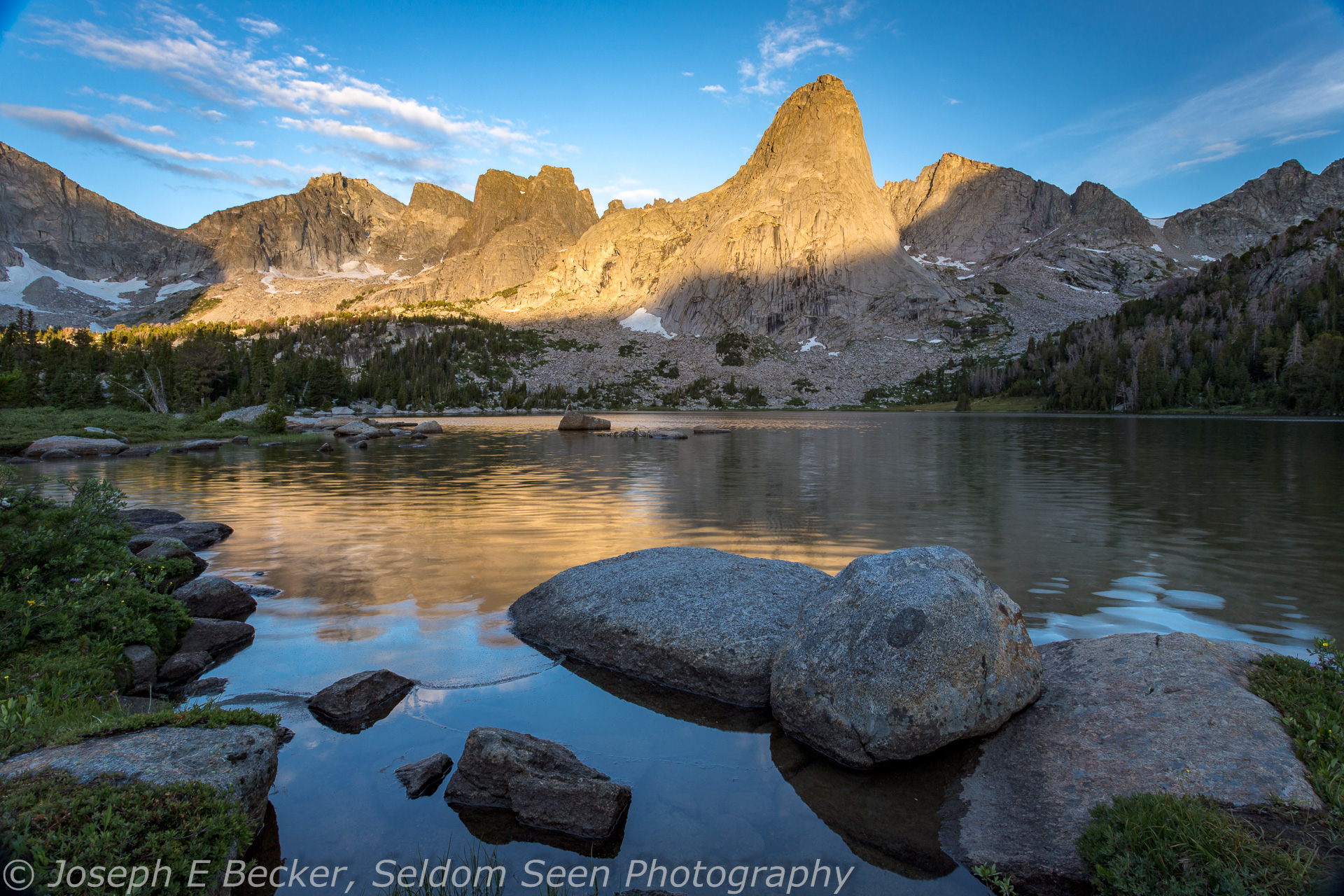
The trail south of Texas Pass leads down past the base of Pingora Peak to Lonesome Lake (on the featured image at the top, Pingora Peak is the prominent one on the left). Though mostly meadows, the trail is once again easy to lose. Just keep heading downhill, an elevation drop of about 1,300 feet in one mile. The trail is east of the small creek that comes out of the small cirque below the pass, cutting through the trees above Lonesome Lake, emerging at the northwest corner of the lake. From there, it skirts the shoreline and meets up with an official trail again right at the outlet stream at the east end of the lake. (Or I should say river, the lake is the headwaters for the North Popo Agie River.)
There is no camping within a quarter-mile of the lake. We found abundant campsites on the southeast side of the lake. The view of the Cirque of Towers, as it surrounds the lake, is spectacular. Unfortunately, the afternoon we arrived, the sky had grown overcast, and it looked like it might rain that night. I took a few photos, but just mainly enjoyed the view and took a nap on a flat boulder “island” along the lake shore.

In the morning, we rose early for sunrise, just in case the clouds had parted in the night. And they had. As the first alpenglow hit the peaks, the lake was a mirror. As the sun rose, lighting more of the mountains, a slight breeze came up, but the view was no less amazing.
Later that morning, we packed up and climbed the trail to Jackass Pass – not nearly as bad as Texas Pass, only gaining 550 feet over a mile – the scenery spectacular all the way. We spent a long time at the pass, climbing the small hill west of it, soaking in the view of the nearby War Bonnet Peak to the west, the rest of the Cirque and Lonesome Lake to the north, and Arrowhead Lake (shaped exactly like an arrowhead) to the southwest.
From Jackass Pass, the trail traverses along the mountainside above Arrowhead Lake then drops about 1,000 feet down to Big Sandy Lake, about 2.4 miles from the top of Jackass. While the elevation between Big Sandy Lake and Jackass Pass isn’t too extreme, both Rob and I were glad we were coming down instead of going up. What’s not included in the 1,000 elevation gain is all the little ups and downs. We both thought coming into the Cirque from the north via Texas Pass was the easier option if doing the loop trip (if doing an in-and-out, coming in via Big Sandy and Jackass Pass is probably easier, but you would miss Shadow Lake that way).
Our original plan was to camp at Big Sandy Lake and hike out the next day. Even though the scenery at Big Sandy Lake is great, after the previous day in the Cirque, it didn’t quite match up, and still being relatively early in the day, we decided to hump it all the way out that afternoon and spend our extra day driving through Yellowstone National Park on the way home. The trail from Big Sandy out to the trailhead is about 5.6 miles and relatively flat, losing only about 600 feet. We set a good pace and made it back to the car before dinner time.
All in all, it was a great backpacking trip. I highly recommend doing the loop. Don’t be afraid of the portion of the trail that is unmaintained and unofficial. For the most part, it is easy to follow, and where it is not, the way to go is fairly obvious. This national-park worthy hike will leave you wanting go back – I can’t wait to go back.


Leave a Reply