 In my last post, I started describing the hike along the North Olympic Wilderness Coast, covering from Shi Shi Beach to Sand Point. Today I finish, covering from Sand Point to Rialto Beach.
As I mentioned, the hiking near Sand Point is perhaps the easiest of the entire 32 miles. This is particularly true south of Sand Point, where the beach is broad and sandy. Though hiking in the dry sand can be tiring, it is possible to walk on wet sand at all but the highest tides (which in summer occur at night on this part of the coast).

South of Sand Point proper, the beach extends for about 2 miles. Then, after going around an easy headland (passable at 5-foot tide or lower – no overland trail), you come to another nice beach at Yellow Banks – so named for several cliffs made of yellow rock inland off the beach. The campsite at Yellow Banks is the furthest south campsite where reservations are required.
South of Yellow Banks is a long stretch of about 4.5 miles with only one headland (passable on a 6-foot tide – no overland trail), but also without a nice walking beach (at least at the tide level we saw it at; we hiked this section on a rising tide). Here the beach is mostly cobbly, instead of sandy. At high tide, the area could be difficult to hike due to the lack of beach (the tide appears to come quite close to the treeline) and due to downed trees that stick out into the water at high tide.
When hiking this stretch of the coast, we came upon a Boy Scout troop heading north. We stopped to talk a minute to get news of the headland we needed to round before coming to our next camp at the Norwegian Memorial. One of the men with the troop was carrying a rib bone from a whale, which, he said, he intended to carry the rest of their hike. (We wondered about the wisdom of that, first because it probably weighed 20 pounds, and second we doubted the park rangers would let him keep it.) They said bone was from a collection of whale bones in the next small cove. A short distance later, we found the bones, many of which someone had placed together on a large drift log.
We rounded a broad, rocky area north of the Norwegian Memorial close to high tide without too much difficulty and rambled out onto Kayostia Beach, a long sandy beach in front which is home to the Norwegian Memorial. The memorial is dedicated to the crew of the Norwegian vessel Prince Arthur, which struck a reef, broke apart, and partially sank just offshore on January 2, 1903. Only 2 of its 20 person crew survived. The memorial is reportedly on a bluff overlooking the northern end of Kayostia Beach, but wanting to get our camp set up, did not go look for it.

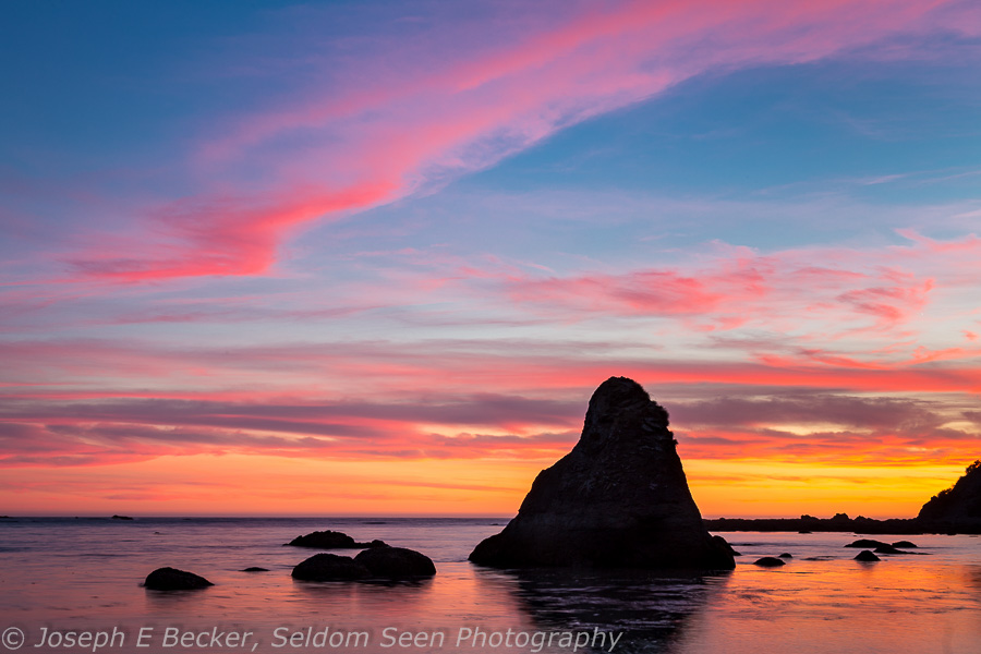
The backcounty campground at Kayostia Beach is about south of the memorial by about half a mile. There are many nice, large sites set just off the beach in the trees. At the southern end of the beach, there is a particularly attractive sea stack and some nice tidepools.
Around the small headland at the end of Kayostia Beach (passable at a 5.5-foot tide, but there is also an overland trail) is an even more beautiful beach. At the northern end of this beach is the Cedar Creek campsite (which we did not visit). The beach lasts for a mile, ending at headland that can be passed on a 4-foot tide (or by overland trail). Past this headland is another nice sandy beach just less than a mile long, which ends a small headland that can only be crossed by going over the top on a short trail (with ropes of course).
South of this headland, the beach becomes rocky again. About midway down this rocky beach, there is a small waterfall in cleft in the rock face a the top of the beach. We spent five hours waiting the the tide near this waterfall because at the south end of this rocky beach is a headland that is passable only at low tide (5.5 feet or lower). Further, a short mile south of the headland is Cape Johnson, which also must be traversed at low tide (4 feet or lower – neither have overland trails). We made the trip around these two headlands on an outgoing tide, with the water level just below the highest recommended levels. The traverse, particularly around Cape Johnson was not easy; but perhaps it is easier with a lower tide. We did see a large number of seals hauled out on the rocks just offshore from the cape.
South of Cape Johnson is a beautiful cove which is home to the Chilean Memorial – which is the resting place of the crew of Chilean ship, W.J. Pirrie. The W.J. Pirrie was torn apart just offshore here in November 1920, killing all but two of the crew of 20.
The beach in the cove is mostly gravel and cobbles, with only a small stretch of sand. That sandy spot forms a small campground. When we arrived on an early Friday evening, the campground was crowded with four of five other groups. One moved over to allow us a spot to camp. Of all the campsite we visited on the trip, this was smallest and most crowded (a result, most likely, of being only 3.7 miles north of Rialto Beach).
South of Chilean Memorial to Hole in the Rock, the coast is formed by two more small coves and plenty of sea stacks offshore. Hole in the Rock is at the last headland before Rialto Beach. The “hole” is a small arch in the bottom of the headland, and at low tide you can walk through it. At high tide, you will need to take the short trail over the top. We took the low route, and the tide was just a little too high to make it without getting wet feet. There is a backcountry campground at Hole in the Rock, but we did not see it.

South of Hole in the Rock, it is an easy beach walk to the parking lot at Rialto Beach. The stretch of coast between the northern end of Rialto Beach and the Chilean Memorial was, in my opinion, some of the most scenic of the entire trip.
Photography Considerations
This hike is high on scenery, and it is very worthwhile to take your camera. I carried my Canon 6D, two lenses (a 28-300mm zoom and a 17-40mm zoom), a tripod, and several filters (a polarizer, a split neutral density filter, and a 10-stop neutral density filter), as well as extra batteries and other small accessories. I used most, if not all, the equipment I brought (partially because if I was carrying it, I thought I should use it). Of course, weight is a consideration as well!
For lens selection, you probably want everything in your bag. There are many sweeping scenic shots for wide-angle lenses. Short telephoto lenses are useful for isolating sea stacks off shore. And longer lenses are a must if you want good wildlife shots (we saw raccoons, deer, a coyote, dozens of bald eagles, great blue herons, seals, and a few sea otters).
A polarizing filter helps a lot with glare, wet surfaces, and minimizing the common sea mist. It is essential for minimizing reflections when shooting tidepools. I found having the 10-stop neutral density filter fun, being able to take long exposures to totally remove wave action. A split neutral density filter was handy at sunset. The tripod was definitely worth taking for those long exposures, sunset shots, and tidepool shots.
Being the west coast, sunsets were good photographic subjects. At most places, with short walks from the campsites, there were almost always sea stacks or islands that could be used in sunset compositions. I didn’t bother much with sunrise, which was typically blocked by the bluffs rising eastward off the beach.


Leave a Reply